3. SECTION 2: METHODOLOGY
The methodology for the report is illustrated in the flowchart below and described in more detail in the text that follows.
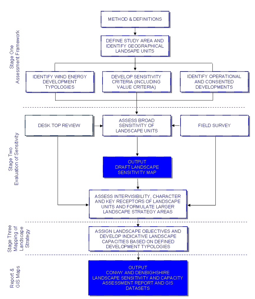
Stage One: Assessment Framework
The methodology was informed by the documents listed in Appendix 1, including guidance developed for use in Scotland which is specific to wind energy development schemes and is widely accepted for use in England and Wales. The following good practice documents were particularly informative:
- Topic Paper 6: Techniques and Criteria for Judging Capacity and Sensitivity (Scottish Natural Heritage and the Countryside Agency, 2006).
- Guidelines for Landscape and Visual Impact Assessment (GLVIA). The Landscape Institute and the Institute for Environmental Management and Assessment (Second edition 2002) replaced by GLVIA Third edition April 2013. This is the industry standard for landscape and visual assessment.
Both Topic Paper 6 and GLVIA advocate the use of professional judgement and an understanding of landscape character to help inform broad assumptions as to what makes one landscape relatively more or less sensitive than another to particular forms of development. Key to this is an understanding of which aspects of the landscape are particularly susceptible to the type of development proposed. These include physical, perceptual and experiential characteristics. The susceptibility of these is first assessed individually before being combined and a judgement for overall sensitivity made through balanced assessment of all the characteristics.
Data Sources
The assessment was informed by data gathered from the sources of baseline information listed in Appendix 1, including maps, relevant landscape and historic character assessments, LANDMAP, field work and consultations with the Steering Group.
LANDMAP
LANDMAP is the formally adopted methodology for landscape assessment in Wales and has been extensively used to inform this study in accordance with GLVIA. LANDMAP is an all-Wales GIS based landscape resource where landscape characteristics, qualities and influences on the landscape are recorded and evaluated into a nationally consistent dataset. LANDMAP comprises five spatially related datasets (layers) - Geological Landscape, Landscape Habitats, Visual and Sensory, Historic Landscape and Cultural Landscape. Information on each is detailed in the LANDMAP Methodology: Guidance for Wales (CCW, 2008).
Each of the five spatial layers are subdivided into discrete geographical units (GIS polygons) referred to as aspect areas. Each mapped aspect area is defined by its recognisable landscape characteristics and qualities. Accompanying each aspect area is a description (Collector Survey record) which describes and documents the landscape character, qualities and features. Management recommendations are also provided, together with an overall evaluation score, contextualised from a local to international scale of importance.
Each Collector Survey records information from the unique perspective of the LANDMAP layer concerned, with each LANDMAP layer being produced independently for each of the five layers. Therefore when key characteristics are referred to across several layers for the same geographic area, the value of their importance is typically emphasised. However, it is only by assessing each layer on its own, that it becomes clear which aspects of the landscape character and qualities are sensitive.
Although GLVIA recommends that data from all five LANDMAP layers should be used in any assessment, the Cultural Landscape information provided in the Cultural Landscape layer was not sufficiently detailed to be useful for this study8.
8 LANDMAP Information Guidance Note 3 doesn’t identify any specific evaluation criteria for Cultural Landscape
Definition of the Study Area and Scale of Mapping
Study Area
As shown in Figure 3, the study covers the whole of the local Planning Authority area for Conwy and Denbighshire, excluding Snowdonia National Park. It includes areas with particular landscape interests notably the Pontcysyllte Aqueduct and Llangollen Canal World Heritage Site, Conwy Castle World Heritage Site, Clwydian Range and Dee Valley AONB, Great Orme Heritage Coast, Cynwyd and Llandrillo AOB, Registered Historic Landscapes and Registered Parks and Gardens.
The assessment took account of coastal and seascape issues only where they were relevant to the assessment of landscape character and sensitivity of the coastline between Lavan Sands (to the north west) and the Point of Ayr (to the north east). Consideration of offshore wind energy developments were not in the remit of the study.
Due to the height of turbines and their wide ranging visual influence, any development will typically affect the landscape in which it is located and also neighbouring landscapes. Existing and proposed wind energy developments beyond the Councils’ boundaries were therefore included in the baseline for the assessment, focusing on those within 10km of the boundary. This report is principally concerned with wind energy developments of smaller to medium scale, therefore for the purposes of this study it was considered that this is the distance where the potential for significant visual effects arising from small to medium scale wind energy developments is most likely to arise.
Scale of Mapping
Landscape sensitivity and capacity studies are typically based on existing local landscape character assessments which subdivide the landscape into landscape character types (LCTs) or landscape character areas LCAs); ideally LCAs (refer to Appendix 7 for definitions). These are then reviewed and the key characteristics of each LCA (or LCT) which are potentially sensitive to any given development (key sensitivity criteria) are identified. Whilst these key sensitivity criteria may vary according to the nature of the development being considered, the methodological approach between studies is generally similar. In this case, there wasn’t a current consistent landscape character assessment covering both Conwy and Denbighshire9. After consideration with the Steering Group, the Clwyd Landscape Assessment 1995 was considered to be the most appropriate baseline for the purpose of this study, due to the following reasons:
- The Clwyd Landscape Assessment covers the most of the study area (approximately 85%).
- Although it was produced 18 years ago the landscape character types within the Clwyd Landscape Assessment are closely linked to the landscape character areas of the more recent Denbighshire Landscape Strategy (produced in 2003), which is based on an analysis of data from the five LANDMAP layers.
- LANDMAP uses the Clwyd Landscape Assessment 1995 as a key data source.
- The landscape character types were generally considered to be of a suitable scale to use as the reporting units for the study.
The Clwyd Landscape Assessment breaks much of the landscape of the study area down into 27 LCTs. For the purpose of this report these LCTs were subdivided into geographical areas and are referred to as landscape units (refer Appendix 7 for definition). The term landscape units has been used for the purpose of this report as the areas are not formally recognised as LCAs.
The 15% of the study area which was not covered by the Clwyd Landscape Assessment was subdivided into three landscape units, primarily based on Special Landscape Areas as described in Conwy’s Revised Background Paper 27 - (August 2012). This approach was endorsed by the Steering Group.
9 Although the Visual and Sensory Aspect Area (VSAAs) boundaries could have been used as the reporting units for sensitivity, the scale of these (>300 across the study area), was considered too detailed for this strategic study.
Figure 5 illustrates the 42 landscape units which were devised. Due to the Clwyd Landscape Assessment plan not being available in GIS or any other digital format, the original paper based plan was scanned in and digitised into GIS format and then overlaid onto a current 1:50,000 OS base of the area.
Landscape and Visual Sensitivity Criteria
A key step in the study process was to identify and understand the aspects of the landscape which are more likely to be affected by wind energy development as it is these characteristics which ultimately define how much development could potentially be accommodated or not in a particular area.
The criteria defined in Table 1.3 and Table 1.4 are based on current good practice and were agreed with the Steering Group. They include criteria relating to landscape character and visual amenity as well as other aesthetic, perceptual and experiential aspects, for example scenic quality, remoteness and tranquillity. They also include criteria relating to the value of the landscape10, as defined by the presence of any landscape designations and undesignated landscapes which have been evaluated by LANDMAP as Outstanding or High11. It is important to emphasise that a landscape which is highly valued by society may still be able to accommodate some wind energy development in the right location - if it fits with the characteristics of the landscape and doesn’t compromise the reason why value is attached to the landscape and in the case of designated landscapes, does not compromise the purpose for designation. Conversely a landscape that isn’t designated may be highly sensitive to wind energy development if it has particular characteristics which are very sensitive to wind energy development.
10 Although not strictly a sensitivity criterion as defined by Topic Paper 6, designated landscapes are typically highly vulnerable to change associated with wind energy development, therefore they were included in the assessment of sensitivity.
11 TAN 8 states that to identify the landscape value of an area, existing information on landscape value derived from LANDMAP should be mapped. A concentration of Outstanding and High evaluation scores in a given area can be significant. However it does not mean a blanket ban on development; it is the underlying information from which the evaluations are derived that must be judged in order to arrive at an assessment of sensitivity based on value.
Table 1.4 identifies the LANDMAP datasets which were used to help assess the sensitivity of each criteria and how they have been used to indicate lower or higher sensitivity. This was supplemented by information from existing assessment work (see Appendix 6).
The sensitivity of each landscape unit within the study area was assessed against each of the sensitivity criteria and graded using a transitional three point sensitivity scale, higher, medium or lower as described in Table 1.2 below.
Table 1.2: Definition of Sensitivity
| Definition | |
| Higher | Areas where the key landscape characteristics are vulnerable and likely to be adversely affected by wind energy development. The landscape would not be able to accommodate wind energy development without significant effects on its character. |
| Medium | Areas where wind energy development may cause some adverse effects on key landscape characteristics; Although the landscape may be able to absorb some development if sensitively sited and designed, it may introduce new inappropriate characteristics or result in a change in character. |
| Lower | Landscapes which taking into account their character and general visibility are not very vulnerable to change and could accommodate some wind energy development without significant adverse effects. |
The overall assessment of sensitivity of each landscape unit was then evaluated and an overall grade of sensitivity was assigned using a more detailed five point sensitivity scale, low, medium, medium-high, high and very-high. This process involved a balanced approach, considering all the assessed criteria and focussing particularly on the susceptibility of the key landscape characteristics of each unit to wind energy developments. All of these evaluations represent the judgement of two qualified and experienced landscape architects, based on both desk top studies and field surveys. The overall evaluations of sensitivity are not based on any mathematical formula (for example – assigning scores and adding up the lower, moderate and higher scores and averaging them out) there is also recognition that sensitivity does vary locally within the landscape units and that the overall evaluation represents the general sensitivity across the landscape unit to reflect the strategic nature of this study.
Table 1.3: Criteria for Assessing Landscape and Visual Sensitivity to Wind Energy Development
| Landscape Criteria |
| Scale: This is one of the most important characteristics affecting where turbines may be more readily accommodated and also in influencing the scale of development that may be appropriate. A large scale expansive landscape is typically less sensitive to large wind energy developments than small scale intimate landscapes. A large height differential between valley floors and hill tops may help reduce sensitivity by lessening the perceived size of the turbines. In both instances care has to be taken to ensure that the apparent scale of the landform is not diminished by the size of the turbines. |
| Landform: Landforms that are smooth, regular and convex, or flat and uniform are likely to be less sensitive to wind energy development than complex varied landforms with distinctive landmarks where visible wind turbines may have a detrimental effect on the appearance and experience of the landform. Complex landforms may provide some screening opportunities for turbines but care has to be taken not to dominate intricate landforms. |
| Landcover Pattern: This criterion is not concerned with the particular material sensitivity of a type of landcover, but with the impression of landcover pattern. Simple uncluttered landscapes with sweeping lines and a consistent groundcover are likely to be less sensitive to wind energy development. Areas of commercial forestry and intensive farming may also indicate lower sensitivity. Complex landscapes comprising a variety or mosaic of characteristic or sensitive landscape features such as trees and woodlands, irregular field patterns and hedgerows are typically more vulnerable to change arising from wind energy development. Tree and woodland cover offers the potential to screen small scale turbines in certain situations (particularly in combination with undulating landform) although care must be taken not to allow turbines to detract from or dominate locally distinctive features such as tree knolls, ancient specimen trees or avenue trees. |
| Built Environment: This criterion is concerned with the presence of built structures and human intervention present in the landscape. The presence of modern structures such as wind turbines, transport, utility or communications infrastructure or industrial development may reduce landscape sensitivity to wind energy development, as may the visible influences of quarrying or landfill. The frequency of built form and human intervention in more contemporary densely settled areas may also indicate a reduced sensitivity to the introduction of wind turbines. However, in all of these cases care must be taken to avoid further visual conflict and cumulative change through the introduction of additional vertical structures. In settled areas there is a balance to be struck between visual effects and effects on landscape character. Areas which are more sparsely settled and/or characterised by a more established, traditional or historic built character, including historic structures are likely to be more sensitive to wind energy development. |
| Visual Criteria |
| Skylines and Settings: Landscapes with distinctive ridges or skylines are likely to be more sensitive to wind energy development than skylines that are less prominent or have been affected by existing contemporary structures such as electricity or communications infrastructure. The presence of distinctive or historic landscape features such as hilltop monuments, church spires or vernacular villages’ increases sensitivity. |
| Movement: Turbines can draw the eye by introducing movement into the landscape. Landscapes that are already affected by movement are therefore likely to be less sensitive, whilst landscapes which are valued for their tranquillity will be more sensitive. |
| Visibility, Key Views, Vistas: This criterion is concerned with views and visual receptors which influence visual sensitivity. The likelihood of turbines being highly visible in the landscape depends on the scale of the development and landform in which it is sited and on the screening opportunities of landcover, especially buildings, trees and woodlands. Landscapes which are visually contained with limited inward and outward views are likely to be less sensitive than open landscapes with extensive inward and outward views. The availability of views of these landscapes from neighbouring areas will also influence sensitivity. Landscapes which are experienced from tourist routes, national or regional trails and other recognised visitor locations are more sensitive to wind energy development. Similarly, close proximity to settlement which increases the chance of adverse effects on visual amenity may increase an area’s sensitivity. |
| Typical Receptors: The numbers and types of people likely to experience a change in a view due to potential development influences visual sensitivity. The most sensitive receptors are likely to be residents, communities, people engaged in outdoor recreation where landscape is part of the experience, visitors to landscape focussed natural and built heritage assets, key amenity and recreational attractions and users of scenic routes. Each location brings with it certain expectations. Transport routes are generally considered less sensitive receptors, however single and sequential views from strategic road and rail routes are important to the perception of the landscape. |
| Intervisibility/Associations with Adjacent Landscapes: Landscape units which have limited intervisibility (inward and outward views to and from adjoining landscapes) are likely to be less sensitive than units which have extensive views. Where adjoining landscapes are intervisible and are of higher sensitivity then this increases the sensitivity of a landscape unit. Where the adjoining landscapes are not intervisible or are of a lower sensitivity, then sensitivity is likely to be lower. The setting of designated landscapes may be more sensitive where the setting contributes to the overall scenic quality of the designated landscape. |
| Views to and from Important Landscape and Cultural Heritage Features: Landscapes which are important to the views in and out and setting of key designated landscape and cultural heritage areas / focal features (such as AONBs, National Parks, World Heritage Sites, Historic Landscapes, Registered Parks and Gardens, Areas of Outstanding Beauty, National Trails and Cycle Networks and key/focal designated visitor attractions such as historic hillforts/castles/church spires) are likely to be more sensitive. |
| Aesthetic, Perceptual and Experiential Criteria |
| Scenic Quality and Character: Areas of attractive scenery, character, quality, integrity, strong sense of place and local distinctiveness will typically be more sensitive to wind energy development than less scenic areas. This includes landscapes designated for their natural beauty (see below) but also areas of undesignated landscape, including areas which are locally distinctive or have strong character. |
| Remoteness/Tranquillity: Areas which are relatively remote and have a wild and/or tranquil character and lack built development increase the sensitivity of the landscape to wind energy development. Turbine development adjacent to such areas can undermine the special qualities and setting of such areas, although if this is associated with and in scale with other forms of development such as farms, the effects may be lessened. |
| Value Criteria |
| Landscape Value: Areas which are predominantly recognised by Outstanding or High LANDMAP evaluations are likely to be more highly sensitive to wind energy development. In addition, landscapes that are formally designated for their scenic, designed or recreational value are likely to be more sensitive to wind energy development than undesignated areas. The degree of sensitivity depends on the nature of the proposal and the landscape qualities which are valued by the designation. The hierarchy of the designation has a bearing on sensitivity of a landscape. Internationally and nationally designated landscapes such as National Parks, World Heritage Sites and AONBs are considered to be very sensitive, closely followed by regional and local designations such as AOBs and SLAs. Landscape value is formally recognised by designation, but value can also be informed by published documentation such as tourist leaflets; art and literature. Heritage Coasts are not protected by designation but are considered to be of national value. |
| Historic Value: Areas which are predominantly recognised by Outstanding or High LANDMAP evaluations are likely to be more highly sensitive to wind energy development. Areas designated for their international, national or regional historic or cultural heritage value such as World Heritage Sites are likely to be more sensitive to wind energy development especially if the character or perception of the landscape in which they are located is likely to be significantly altered. Registered Historic Landscapes and Registered Parks and Gardens are not protected by designation but are considered to be of national value. |
Table 1.4: Source of Data Relevant to the Sensitivity Criteria
| Characteristic | LANDMAP Data Source (other data sources will be used) | Some Indicators of Lower Sensitivity to Wind Energy Development | ⇔ | Some Indicators of Higher Sensitivity to Wind Energy Development |
| Landscape Criteria | ||||
| Scale | VS8: Scale |
|
⇔ |
|
| Landform | VS4: Topographic Form |
|
⇔ |
|
| Landcover Pattern |
VS3: Landcover VS5: Landcover Pattern |
|
⇔ |
|
| Built Environment |
VS6: Settlement Pattern VS27: Condition |
|
⇔ |
|
| Visual Criteria | ||||
| Skylines & Settings | Topographic data |
|
⇔ |
|
| Movement | VS18: Level of Human Access |
|
⇔ |
|
| Visibility, Key Views, Vistas and Typical Receptors (both within and outside of each landscape unit) | VS9: Enclosure |
|
⇔ |
|
| Intervisibility/associations with Adjacent Landscapes |
|
⇔ |
|
|
| Views to and from Important Landscape and Cultural Heritage Features (both within and outside of each landscape unit) | National Park, Area of Outstanding Natural Beauty, World Heritage Site, Area of Outstanding Beauty, Heritage Coast, National Trails and National Cycle Routes, Registered Historic Landscape, Registered Park and Garden (for the purpose of this strategic study Listed Buildings and SAMs are considered only if valued as a key visitor attraction or focal point). |
|
⇔ |
|
| Aesthetic, Perceptual and Experiential Criteria | ||||
| Scenic Quality and Character |
VS46: Scenic Quality VS47: Integrity VS48: Character Sense of Place |
|
⇔ |
|
| Remoteness/Tranquillity | VS24: Perceptual and Sensory Qualities |
|
⇔ |
|
| Landscape Value |
Designated site/nationally valued site/regionally valued site or its setting VS50: Overall Evaluation VS49: Rarity LH45: Overall Evaluation LH42: Connectivity / Cohesion GL31: Rarity / Uniqueness GL33: Overall Evaluation |
|
⇔ |
|
| Historic Value |
Designated site/nationally valued site/regionally valued site or its setting HL38: Rarity HL35: Integrity HL40: Overall Evaluation |
|
⇔ |
|
Stage Two – Assessing Landscape and Visual Sensitivity
This part of the study involved desk and field survey, the latter being undertaken both in the early stages of the study (familiarisation) and later to help verify and refine the desk based sensitivity assessments.
Baseline Assessment
The first step in the process was to:
- Identify and evaluate the existing landscape of the study area, including its distinctive characteristics, existing landscape designations and effects of existing wind energy developments.
- Identify and evaluate the existing views and visual amenity of the study area.
- The following information was reviewed as a desk exercise:
- Ordnance Survey maps and aerial photography.
- Designated and nationally/regionally valued landscapes, including the Clwydian Range and Dee Valley AONB, Cynwyd and Llandrillo AOB, SLAs, Registered Historic Landscapes, Registered Parks and Gardens.
- Information from LANDMAP datasets (all five Aspect Areas).
- Natural and Built Heritage GIS mapping data.
- Existing landscape character assessments.
- Registered Historic Landscapes, including Dyffryn Clwyd (The Vale of Clwyd), Pen Isaf Dyffryn Conwy (Lower Conwy Valley), Creuddyn a Chonwy (Creuddyn and Conwy), Gogledd Arllechwedd (North Arllechwedd), Y Berwyn (Berwyn), Pen Isaf Dyffryn Elwy (Lower Elwy Valley), Mynydd Hiraethog (Denbigh Moors), Dyffryn Llangollen ac Eglwyseg (Vale of Llangollen and Eglwyseg), Comin Treffynnon a Mynydd Helygain (Hollywell Common & Halkyn Mountain) , Pontcysyllte Aqueduct and Canal World Heritage Site, Registered Parks and Gardens and visually prominent Scheduled Monuments.
- Existing wind energy developments within the study area.
The findings of the desk survey, which were subsequently refined following field survey work, are presented in Section 3. They include an overview of the key landscape characteristics of the study area, a description of existing and consented wind energy developments and their effect on the landscape and comments on any issues of existing and potential cumulative effects.
Assessing the Sensitivity of Landscape Units (LUs)
This part of the study required the preparation of sensitivity assessment sheets for each landscape unit, as presented in Section 4.
The key features of each landscape unit are described before being evaluated against the sensitivity criteria described in Table 1.3 and Table 1.4 using a three point grading: higher, medium or lower (described in Table 1.2, Section 1). Those characteristics which are considered particularly susceptible to development are highlighted. Finally a judgement on the overall sensitivity of each landscape unit to change associated with wind energy development is made, based on a more detailed five point sensitivity scale: low; medium; medium-high; high; and very high.
Appendix 6 includes a CD containing 21 plans which represent data taken from LANDMAP overlaid onto the study area (as listed in Table 1.4). This information was used to make initial judgements on sensitivity which was then backed up and or moderated following further desk top studies and the site visits.
Field Survey
On completion of the draft assessment, field surveys were undertaken to help test and refine the findings and provide the following information:
- Better understanding of the general characteristics of the landscape including the effects of existing wind energy developments and any forces for change which it may be experiencing.
- Analysis of the landscape, in terms of the characteristics and qualities which affect its sensitivity to wind energy development, including the special qualities of any designations which apply.
- Appreciation of the variations within individual landscape units and more detailed understanding of scenic quality and landscape condition.
- Appreciation of the nature of any visual amenity issues.
- Understanding of the degree of intervisibility, both between landscape units within Conwy and Denbighshire and with landscapes in neighbouring authority areas.
- Important views to and from each landscape unit were recorded, identifying distinctive features such as iconic viewpoints, views to and from designated landscapes, skylines or uninterrupted horizons (both land and sea). It is important to understand how the landscape is experienced both from fixed viewpoints and sequentially as people travel through an area.
- Understanding of how individual characteristics either alone or in combination make one landscape more sensitive than another. This helped identify any specific strategic sensitivity / capacity constraints which may reduce the potential of particular landscape areas to accommodate wind energy development.
The fieldwork also briefly considered the likely implications of the different wind energy development typologies in relation to different aspects of the landscape. The acceptability of the different wind energy development typologies varies across all landscape units. In small scale sheltered valleys for example, there are clear technical constraints to large and medium typologies. Similarly, areas with significant landscape sensitivities to large scale development such as the Clwydian Range and Dee Valley AONB, may only be suitable for single very small turbines.
Based on the results of the field surveys, the draft evaluations of landscape unit sensitivity were refined and the final sensitivity assessment and accompanying summary tables for each landscape unit prepared.
Combining Landscape Units into Landscape Strategy Areas
The final step in Stage Two involved combining the landscape units into larger landscape strategy areas. This was informed by the sensitivity assessments, supplemented by an analysis of intervisibility, key visual receptors, topography (including ridgelines and water-sheds based on LANDMAP information), Ordnance Survey and GIS data, landscape character, observations made during field studies and discussions with the Steering Group.
A judgement was then made on the overall sensitivity of each of these strategy areas based on an assessment of their constituent landscape units. To allow for more refined judgement, the overall sensitivity of strategy areas was judged on a five point scale - low, medium, medium-high, high and very high. As before, these levels are based on professional judgement rather than a mathematical scoring system or matrix analysis as discussed previously.
Stage Three – Assigning Landscape Strategies and Developing Siting and Design Guidance
This stage in the study applied professional judgement to determine the most appropriate landscape objective(s) and the relative capacity of each of the identified strategy areas by combining the landscape and visual sensitivity evaluation with issues of intervisibility and potential cumulative effects that may arise should further development take place.
Wind Energy Development Typologies
Landscape capacity for wind energy development reflects not only the presence of different landscape characteristics and values, but also the grouping and height of the turbines in relation to the scale of the landscape. To help evaluate this, a series of generic wind energy development typologies based on past wind energy development applications and anticipated future trends, was identified.. The almost endless possible permutations of turbine numbers and heights made the choice of an appropriate range of typologies difficult. There was, however, a clear need to establish appropriate typologies to enable the provision of meaningful guidance, including guidance on single and pairs of turbines below 60m to blade tip, which are becoming increasingly common in planning applications and enquiries.
The five categories (micro, small, medium, large, and very large) which were identified and agreed with the Steering Group are is presented in Table 1.5 overleaf and illustrated in Figure 9 in comparison to other well-known local landmarks to provide a sense of scale.
A proposal will normally be considered as falling within the category that represents the biggest type for which it qualifies.
Table 1.5: Wind Energy Development Typologies
|
Wind Energy Typology |
Indicative Output (broad output category12)
|
Supplementary Criteria (meets one or more of the criteria)(determines whether this typology applies or whether a larger one does) |
|
Micro |
under 50kW |
Single or twin turbine applications Turbine up to 20m to blade tip |
|
Small |
under 5MW |
Turbines up to 3 in number Turbines up to 50m to blade tip Viewed as a small group |
|
Medium |
over 5MW and up to 25MW |
Turbines up to 9 in number Turbines up to 80 metres to blade tip Viewed as a large group |
|
Large |
over 25MW |
Turbines over and including 10 in number Turbines up to 80 metres to blade tip Viewed as a large scale wind farm |
|
Very Large |
Over 25MW |
Turbines over and including 10 in number Turbines over 110 metres to blade tip Viewed as a very large scale wind farm |
|
Strategic |
Over 50MW |
Turbines over 15 in number Turbines over 100 metres to blade tip Viewed as a nationally strategic Located within the SSA Applications for which are determined by National Infrastructure Planning delivered through PINS. |
12These values are for guidance only and should not be taken as a criterion for determining typology. Efficiency and energy outputs are continually subject to advances in technology and operational efficiency, therefore it is recognised that these values are likely to change.
Applications and enquiries for smaller to medium scale wind energy projects are applicable to the wider study area. Here, turbine height (rather than just the number of turbines) and how this relates to landscape scale and landform, is a key consideration as well as localised issues including settlement separation, views from settlement edges and routes. Applications and enquiries for large and very large scale wind farm developments are most commonly associated with TAN 8 SSA A. The large and very large typologies have been included within Table 1.5 above for reference; however, the capacities for these categories are not dealt with as part of this study, as developments of this scale are not considered to be appropriate outside the TAN 8 Area.
Whilst output is used to define different scales of wind energy development in the Councils’ emerging Local Development Plans, there are a number of specific conditions (in relation to height, rotor diameter or number of turbines), which influence the landscape and visual effect of a proposal and which can therefore change the categorisation of a proposal regardless of output. Indicative outputs are presented in Table 1.5 for reference; however, this information should not be used to determine which typology applies to proposed wind energy developments.
Landscape Objective + Indicative Overall Capacity = Landscape Strategy
Landscape Objectives
The Design Commission for Wales (DCfW) in its 2012 document, Designing Wind Farms in Wales, applied Scottish Natural Heritage (SNH) guidance to the development of its own guidance relating to the development of wind farms. In this document three landscape objectives are discussed in relation to ‘wind farm’ developments as follows:
- Landscape Protection: a ‘landscape with no wind farms or infrequent wind farms’.
- Landscape Accommodation: a ‘landscape with occasional wind farms’.
- Landscape Change: a ‘landscape with wind farms’.
This landscape sensitivity and capacity assessment for wind energy development was commissioned to identify the sensitivity of the landscapes of Conwy and Denbighshire, specifically in relation to ‘wind energy’ development as opposed to ‘wind farm’ development. The above DCfW guidance has therefore been slightly modified and an extra objective added to reflect the scales of wind energy development which are being addressed in this report. It is important to note that these should not be seen as rigidly prescriptive objectives.
| Objective 1 | ||
| Landscape Protection | Typically no wind energy development or very infrequent smaller scale wind energy development | |
|
Landscape protection is applicable to landscapes where the conservation of resource and visual experience of the landscape has been assessed to be of very high importance. It aims to retain or reinforce the present character, quality and integrity of the landscape. It is likely to be difficult to accommodate anything more than ‘micro scale’ wind energy development in such areas. Micro scale development may be acceptable where this relates well to the existing built environment. Whilst smaller scale wind energy development may be appropriate in certain circumstances within areas where landscape protection is the primary objective, such opportunities are likely to be very limited due to the landscape and visual sensitivities of these areas and is dependent on how well the scale and design of development relates to the existing landscape and visual constraints. With tall structures such as turbines, intervisibility between strategy areas must be carefully considered to avoid adverse landscape and visual effects arising from multiple developments. |
||
|
Where a landscape designation is in place, it is important to understand how wind energy development could affect the special qualities for which it is designated. PPW (Edition 5, 2012) aims to maintain the integrity and quality of the landscape within the National Parks, Area of Outstanding Natural Beauty (AONB), Natura 2000 Habitat Directive Sites, National Nature Reserves and World Heritage Sites. In these areas, ‘landscape protection’ will be the most appropriate landscape objective, reflecting the high degree of protection afforded these designated areas. As such they are all excluded from TAN 8 SSAs. |
||
| Objective 2 | ||
| Landscape Accommodation | Typically a landscape with occasional wind energy developments | |
|
Landscape accommodation is applicable to landscapes where the conservation of landscape character and visual amenity has been assessed to be of moderate to high importance. This objective aims to retain the overall character, quality and integrity of the landscape, whilst accepting that occasional small to medium scale developments may be allowed. Such development may have an effect on the local landscape but should not bring about large scale changes in character. |
||
| Objective 3 | ||
| Landscape Change | Typically a landscape with relatively frequent wind energy developments | |
|
Landscape change is applicable to landscapes where it is accepted that the landscape character can accommodate some change as a result of wind energy development. The landscape change objective accepts that medium to larger scale developments may be allowed which may have an effect both locally and across a wider area. In such areas it is important to ensure that turbines do not become a major feature of the landscape and that they fit in with the scale and character of the landscape. |
||
| Objective 4 | ||
| New Landscape | Typically a landscape with a notable amount of wind energy developments - a wind farm landscape | |
| Within (and immediately adjacent) to the SSAs, the implicit objective is to accept a significant change in landscape character resulting from wind turbine development located within the SSA. Where it is accepted that the area is one whose landscape character may be allowed to change, DCfW considers that good landscape design principles still need to be followed to ensure that the development is appropriate to the scale and character of the landscape. | ||
Each landscape strategy area is assigned a landscape objective, or in some cases several landscape objectives, to assist the Councils’ decision making on new applications. These landscape objectives then form the basis for recommendations on the wind energy development typologies which may be appropriate in each of the strategy areas.
The relationship or thresholds of landscape change that may arise from development vary depending on the landscape and the nature of the potential development. It is assumed however that there is typically higher capacity for wind energy development in areas of lower sensitivity where landscape change is considered more acceptable. Conversely areas of higher sensitivity, particularly those which are designated are likely to have very limited capacity. In addition, larger strategy areas may be able to accommodate a greater number of developments.
Indicative Landscape Capacity
An overall indicative landscape capacity has been derived for each landscape strategy area by considering the following:
- Overall landscape and visual sensitivity to wind energy development which determines the objective for the area.
- The range of visual experiences; how the landscapes of the area are seen and contribute to strategic and local issues.
- Operational and consented wind energy developments within and adjacent to each landscape strategy area.
- The size of each visual compartment. There may be scope for a greater number of developments within large strategy areas before a capacity threshold is reached.
Whilst the indicative landscape capacity helps to identify the type of developments which could be potentially accommodated, this does not in itself suggest that planning applications for wind energy development in these areas will be appropriate. Other variables such as environmental designations and technical constraints, the site specific siting, layout and design and need for the development are beyond the scope of this assessment and will need to be considered on a case by case basis.
The general relationship between landscape sensitivity, landscape objectives and capacity is illustrated below.
| Landscape Sensitivity | Landscape Objective | Landscape Capacity | Threshold |
| Higher Sensitivity |
Landscape Protection Landscape Accommodation |
Limited Capacity |
No wind energy development or very infrequent smaller scale development
A landscape with occasional wind energy development |
| Landscape Change | Typically a landscape with relatively frequent wind energy developments | ||
| Lower Sensitivity | New Landscape | Highest Capacity | Typically a landscape with a number of wind energy developments essentially a wind farm landscape |
Siting and Design Guidance in Relation to Potential Landscape and visual Impacts of Wind Energy Development
Guidance has been formulated for each strategy area to help direct development to the most appropriate locations in landscape and visual terms. This guidance broadly indicates what type(s) of wind energy development (if any) may be considered appropriate and highlights specific design and siting issues. Any specific constraints which may reduce the potential of particular areas to accommodate wind energy development are noted as are any potential cumulative and cross boundary effects of wind energy development.
A number of more general guidance notes have also been developed to be read alongside this specific guidance; these are found in Section 6.