1. Executive Summary
Background
Conwy County Borough Council and Denbighshire County Council (the Councils) both have a significant expanse of rural upland areas which have an abundant onshore wind resource. For the purposes of the SPG, the area covered only relates to Conwy County Borough. This includes Clocaenog Forest which has been designated as one of seven Strategic Search Areas (SSAs) in Wales, as defined in TAN 8. The Welsh Government’s approach to wind energy development is to concentrate the development of large scale (>25MW) wind farms within Clocaenog Forest Strategic Search Area and the other SSAs, in order to contribute to the Welsh Government’s aspiration to achieve 2GW in total capacity by 2015/2017 (of which 800MW of onshore and offshore wind energy is expected to be provided). 1
1 Ove Arup & Partners (2005), TAN 8 Annex D Study of Strategic Search Area A – Clocaenog Forest Final Issue Report
The identification of Clocaenog Forest SSA has led to some large wind energy developments being consented and constructed. Whilst it is recognised that renewable energy development is important to meeting sustainability targets, there does need to be a balance struck between accepting change to landscape character in some areas whilst protecting other areas that may be more susceptible to change.
Welsh Government planning policy does not set out spatial limitations for onshore wind energy development under 25 megawatts (MW) and those smaller developments under 5MW both of which are applicable to all parts of Wales subject to the assessment of localised impacts.
Conwy comprises a diverse mix of landscapes many of which are highly valued for their great natural beauty and tranquillity - ranging from remote and wild uplands and moorlands to narrow steep sided valleys, wide river floodplains, gently undulating pastoral lowlands and dramatic coastlines. The busy coastal resort towns along the north coast contrast markedly with the highly rural areas inland.
These landscapes are experiencing an increasing number of planning applications and enquiries for wind energy developments under 5MW, (i.e. applications for single and pairs of wind turbines) as well as larger wind energy schemes being progressed outside the SSA.
This study was commissioned by the Councils in response to this growing pressure on the landscape from wind energy developments. The study provides an evidence based assessment of the relative sensitivity and capacity of Conwy’s landscape to accommodate wind energy development of varying scales; focussing on smaller scale developments (typically up to a group of 9 wind turbines and 80m maximum height to blade tip).
This study does not generally consider larger wind energy developments (typically a group of 10 turbines or more, over 80m in height to blade tip) as due to the high sensitivity of the landscapes throughout Conwy these are generally deemed inappropriate outside Clocaenog Forest SSA.
Table 1.5 below illustrates the wind energy development typologies (types/scales) that were identified in collaboration with the Steering Group for the purpose of this study:
Table 1.5: Wind Energy Development Typologies
|
Wind Energy Typology |
Indicative Output (broad output category2) |
Supplementary Criteria (meets one or more of the criteria) (determines whether this typology applies or whether a larger one does) |
|
Micro |
under 50kW |
|
|
Small |
under 5MW |
|
|
Medium |
over 5MW and up to 25MW |
|
|
Large |
over 25MW |
|
|
Very Large |
Over 25MW |
|
|
Strategic |
Over 50MW |
|
2These values are for guidance only. Efficiency and energy outputs are continually subject to advances in technology and operational efficiency, therefore it is recognised that these values are likely to change
As stated previously, applications and enquiries for large and very large scale wind farm developments are most commonly associated with Clocaenog Forest SSA. The large and very large typologies have been included within Table 1.5 above for reference; however, as noted above, the capacities for these categories are not dealt with as part of this study.
Aim of the Study
The overall aim of the study is to provide strategic Supplementary Planning Guidance and to assist the Council in assessing the landscape and visual effects of onshore wind energy development for development control purposes with a view to minimising the effect of such developments on the landscape in line with policies NTE/4 and NTE/7 of the LDP.
Policy NTE/4 – THE LANDSCAPE AND PROTECTING SPECIAL LANDSCAPE AREAS
- Special Landscape Areas are shown on the proposal map and designated in the following locations:
- Great Orme and Creuddyn Peninsula
- Conwy Valley
- Abergele hinterland
- Elwy and Aled Valleys
- Hiraethog
- Cerrigydrudion and the A5 corridor
- In order to conserve the attributes of the Special Landscape Areas development proposals will have to show particular regard to the character of each locality in order to minimise their impact. Development will only be permitted if it is shown to be capable of being satisfactorily integrated into the landscape. In appropriate cases planning applications should be accompanied by a Landscape and Visual Impact Assessment to assess the visual and landscape impacts of the development.
- All proposals, both within and outside SLAs, will be considered against the Development Principles and other policies in the Plan designed to protect the environment and landscape character.
Policy NTE/7 – ONSHORE WIND TURBINE DEVELOPMENT
- The development of large or very large-scale (over 25MW) wind farms will be concentrated within the Clocaenog SSA in accordance with Policy DP/6 and be subject to a satisfactory Environmental Impact Assessment. Proposals will be expected to:
- Demonstrate measures for the safeguarding, remediation and enhancement of habitat and species and conform to the principles contained in the Clocaenog Statement of Environmental Master Planning Principles (SEMP);
- Ensure all details of associated ancillary development are submitted with the planning application as an integral part of the scheme;
- Ensure that the potential cumulative impacts on surrounding communities, landscape and environment are considered acceptable. Where the development of a wind farm is considered to have an unacceptable cumulative impact it will be refused;
- Demonstrate that the development will not lead to noise levels or shadow flicker that would be detrimental to the residential amenity of the surrounding area.
- Outside the Clocaenog SSA the development of medium-scale wind farms over 5MW and below 25MW will only be approved in exceptional circumstances in the context of the following:
- Acceptability in terms of other Local Development Plan policies;
- The potential cumulative impacts on surrounding communities, landscape and environment are considered acceptable. Where the development of a wind farm is considered to have an unacceptable cumulative impact it will be refused;
- The development will not generate noise levels or shadow flicker that would be unacceptably detrimental to the amenity enjoyed by nearby residents or by users of public rights of way or other recreational facilities or areas;
- A satisfactory Environmental Impact Assessment should propose measures for the safeguarding, remediation and enhancement of habitat and biodiversity;
- Where possible, turbines are located no less than 500 metres from an occupied dwelling or other noise-sensitive building;
- Within SLAs wind turbine schemes medium-scale or larger will be resisted;
- Exceptional circumstances are considered to be where there is an overriding need or capacity issue which cannot be met within the SSA.
- Micro and small scale wind turbine development (5MW and less) will only be supported where:
- It is of a proportionate scale in terms of predominant energy production to supply the building(s) which it directly serves;
- It does not compromise the ability of the SSA to achieve its anticipated target of energy production;
- Criteria 2 a) – f) above are met and where appropriate a satisfactory EIA has been submitted;
- Within SLAs wind turbines will not be permitted unless serving a dwelling or cluster of dwellings at micro scale.
Study Objectives
The objectives of the study are to:
- Provide a strategic assessment of the relative sensitivity of Conwy and Denbighshire’s landscapes for wind energy development using a defined set of landscape and visual criteria that includes both physical and perceptual aspects as well as a consideration of landscape value.
- Identify the key landscape, visual and perceptual sensitivities of different landscape areas.
- Provide broad guidance on those landscape areas where wind energy development of different scales is potentially most acceptable and those landscape areas where development is likely to result in unacceptable adverse landscape and visual effects.
- Comment on any likely cumulative and cross boundary effects of wind energy development.
Methodology
There is currently no formally agreed approach for assessing the sensitivity or capacity of landscapes for onshore wind energy development. The methodology set out in Section 2 of the report is developed from current guidance and the approach taken in other similar studies and tailored to this geographically unique study area. It is based on the premise that wind energy development could be more readily accepted in the least sensitive areas and should avoid areas that are highly valued for their scenic, recreational and undeveloped qualities such as tranquility and remoteness; particularly those areas safeguarded by international or national designations and those where the cumulative effects of existing and consented wind energy schemes limit further development.
Professional judgment and understanding of landscape character is used to make broad assumptions, for instance what makes one landscape more or less sensitive than another. These evaluations have been informed and backed up by data gathered from the sources of baseline information listed in Appendix 1, including maps, relevant landscape and historic character assessments, LANDMAP, field work and consultations with the Steering Group.
It is important to note that this report represents a strategic study and is not prescriptive at an individual site level. It does not replace the need for the Council to assess individual planning applications or for specific local landscape and visual impact assessment as part of formal Environmental Impact Assessment on a case by case basis.
It is also important to note that the study is not a cumulative appraisal of wind energy developments. It is also limited to landscape character and visual amenity issues. It does not take account of other natural and cultural heritage considerations (except where they relate to landscape character and visual amenity, including setting), technical factors such as wind speed, grid capacity or aviation constraints or the perceived need for wind energy development. The study focuses on smaller scale wind energy developments and does not consider the remaining capacity of Clocaenog Forest SSA.
Evaluation of Landscape Units and Their Sensitivity for Wind Energy Development
Studies such as this are typically based on existing local landscape character assessments which sub divide the landscape into landscape character types (LCT) or landscape character areas (LCA) (refer Appendix 7 for definitions). For the purpose of this report, in lieu of a current consistent landscape character assessment, the Study Area (Figure 2) was broken down into landscape units which are primarily based on discrete geographical areas of the landscape types identified in the Clwyd Landscape Assessment undertaken in 1995 (refer Section 2, Methodology).
A total of 42 landscape units were identified across Conwy and Denbighshire; these are broadly representative of different character areas of the landscape but are not formally recognised as LCAs).
Data for each these geographical areas was reviewed and site visits made to back up the findings and to inform evaluations of landscape sensitivity for wind energy developments, as follows:
- 21 LANDMAP layers were reviewed and analysed.
- Desk top studies were reviewed including but not limited to the following: Clwyd Landscape Assessment; Denbighshire Landscape Strategy; Seascape for Wales; Cadw Historic Landscapes; World Heritage Site information; and many more.
- Site visits were made to back up and moderate the findings.
The overall findings of the sensitivity assessments are illustrated in Section 4 and summarised in Table 4.1 below.
Table 4.1: Summary of Sensitivity
Evaluation of Landscape Strategy Areas and Capacity Assessments
For the purpose of assessing the capacity of the landscape for wind energy development the 42 landscape units were combined into 15 larger landscape strategy areas. This process was informed by reviewing the sensitivity assessments, supplemented by an analysis of intervisibility, key visual receptors, topography (including ridgelines and water-sheds based on LANDMAP information), Ordnance Survey and GIS data, landscape character, observations made during field studies and discussions with the Steering Group.
A judgement was then made on the overall sensitivity of each of these strategy areas based on an assessment of their constituent landscape units. A statement of the overall sensitivity of the strategy area in relation to wind energy development is presented within each landscape strategy evaluation, together with a justification of the assessment. This justification includes a list of the landscape, visual and cultural heritage characteristics and qualities which are susceptible to wind energy development. The overall sensitivity assessments for the landscape strategy areas are illustrated in Section 5 and summarised in Table 5.1 below
Table 5.1: Summary of Strategy Areas and Overall Sensitivity
| Landscape Strategy Area | Overall Sensitivity | Landscape Strategy Area Location | Page Number | ||
| Ref | Name | Conwy | Denbighshire | ||
| 2 | Vale of Clwyd | High | 5% | 95% | 102 |
| 3 | South Clwydian Hills | Medium-High | 5% | 95% | 104 |
| 7 | Clocaenog Forest | Low | 50% | 50% | 106 |
| 8 | Cerrig Uplands | High | 90% | 10% | 108 |
| 9 | Denbigh Moors | High | 80% | 20% | 110 |
| 10 | Rhos Hills | High | 60% | 40% | 112 |
| 11 | Elwy Valley | High | 95% | 5% | 114 |
| 12 | Conwy Valley | High | 100% | 116 | |
| 13 | North West Conwy Coast | High | 100% | 118 | |
| 14 | Colwyn Coast | High | 95% | 5% | 120 |
| 15 | Coastal Flats | Medium | 45% | 55% | 122 |
The landscape strategy for each of the 15 LSA areas is set out separately and includes the landscape objective(s) for the area, a record of operational and consented wind energy development (March 2013), an indication of the types of wind energy development which might be accommodated (indicative capacity) and some broad guidance notes regarding the scale, design and siting of wind energy developments.
It is important to note that the strategy area evaluation sheets must be read together with the relevant sensitivity evaluation sheets to gain a full appreciation of the sensitivity and capacity of the landscape in relation to wind energy developments.
Guidance for Wind Energy Development Within Strategy Areas
Additional generic guidance notes for the siting and design of wind energy developments are included in Section 6.
Conclusion
Conwy is enveloped by two nationally designated landscapes, Snowdonia National Park which lies immediately to the west of the study area and the Clwydian Range and Dee Valley AONB much of which lies within the eastern part of the study area. The distance between these two highly valued landscapes ranges from approximately 20 km to 35 km and there is good intervisibility between the higher parts of each.
Taking the above into consideration and the fact that Conwy comprise a diverse mix of landscapes (many of which are highly valued for their natural beauty and special qualities such as tranquillity and/or remoteness) much of the study area is considered to be highly sensitive for wind energy developments.
The study identifies some capacity for mostly micro and small scale wind energy developments but little capacity for anything larger.
This report provides a good starting point for identifying the key landscape and visual issues that should be taken into consideration when looking at individual development applications as the document will be used as a material consideration when assessing development.
It provides a strategic overview of the sensitivity and capacity of Conwy’s landscapes for wind energy development, and helps answer the following questions:
- What types of landscapes does Conwy have?
- Why are these landscapes sensitive (or not) for wind energy developments?
- How sensitive are the area’s landscape for wind energy developments?
- What types of wind energy could potentially be accommodated without compromising the integrity and value of the landscape?
- How could wind energy development be designed/accommodated to minimise adverse landscape and visual effects?
The text below summarises how it is anticipated that this report will be used to assist decision makers with regard to assessing wind energy development proposals.
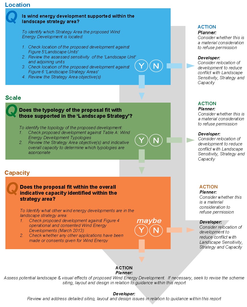
How to Use This Report
The text below and accompanying flow chart diagram represents a brief guide on how to use the Landscape Capacity and Sensitivity Assessment for Wind Energy Development report.
Sensitivity of Development Location
- Review Figure 5 Landscape Units
- Which landscape unit is the proposed development located in?
- Review the evaluations of the sensitivity of the landscape unit and Figure 3 Landscape and Cultural Heritage Designations / Constraints taking into consideration the descriptions of intervisibility and also reviewing adjacent landscape units where strong associations are identified.
- List the key landscape features which are sensitive to wind energy development within the landscape unit which the proposal is located.
Proposed Scale of Wind Energy Development
- Review Table 1.5: Wind Energy Development Typologies
- What is the typology is deemed the ‘best fit’ for this proposed development?
Landscape Strategy and Capacity
- Review Figure 6 Landscape Strategy Areas
- Within which landscape strategy area is the proposed wind energy development located?
- Review the Landscape Strategy for this Area
- What is the landscape objective for this strategy area? What does this objective mean? (detailed descriptions are included in Section 2: Methodology Landscape Objectives)
- Review Figure 4 Operational and Consented Wind Energy Developments (March 2013) and accompanying Table A41: Operational and Consented Wind Energy Developments (March 2013)
- What developments already exist in this strategy area?
- Are you aware of any additional wind energy developments that have been consented / constructed in the landscape strategy area since March 2013?
- Are there any wind energy developments within neighbouring strategy areas or within the study area buffer that may influence the viability of this development? In order to answer this question it would be useful to obtain details of zones of theoretical visibility (ZTV) relating to any such other developments to identify where potential cumulative impacts may arise. ZTV may have been submitted as part of an Environmental Impact Assessment (EIA) or landscape and visual impact assessment (LVIA) – check with planning authority.
- Review the Indicative Overall Capacity for the area
- Is there sufficient information to put a case forward which demonstrates that this proposed development falls within the indicative capacity for the area?
- Is there any evidence to suggest that this development may give rise to any cumulative landscape or visual effects?
- Review the guidance on siting for this landscape strategy area
- Consider and note down any guidance which may have implications on this particular proposed development.
Offer advice
- Use the landscape strategy evaluation, indicative overall capacity and guidance on sitting turbines (backed up by cross referencing the evaluation of the relevant landscape units and their sensitivity for wind energy development) to advise perspective applicants on what needs consideration in the application.
Applicants are to address these issues in the application justification statement (be that Design Access Statement/Landscape and Visual Impact Assessment/Environmental Impact Assessment).
Guide to using the Landscape Sensitivity & Capacity Assessment to Wind Energy Development Report
Key Question Approach