3. Section Three - Spatial Strategy and Key Diagram
3.1 Spatial Strategy Summary Statement
The Conwy LDP strategy is a ‘hybrid’ strategy which provides development in locations that contribute to meeting local needs whilst promoting sustainable growth. This is achieved by targeting development in the priority accessible urban strategic hub locations and in areas of decline and in need of regeneration, but at the same time ensuring that rural communities are fostered through the provision of sustainable levels of local accessible jobs and services. It is an essential element of the strategy that the level of development reflects the roles and functions of individual settlements.
The Spatial Strategy is formed on a number of key component parts shaped from the priority issues, vision and objectives and further underpins the policies in the LDP. The level of growth and the overall approach to sustainable distribution has been influenced by a number of key strategy components to ensure future development is right for Conwy as indicated in table 2 below:
| Table 2: Key Strategy Components and Relationship with LDP Spatial Objectives | |
| Key Strategy Components | LDP Spatial Objectives |
| 1. Having regard to National, Regional and Local Policy and Evidence. | All |
| 2. Promoting a sustainable and balanced approach to managing future housing and employment growth and reduction in out-commuting levels. | 1, 3, 4, 5 |
| 3. Ensuring flexibility through the provision of a housing and employment contingency land supply and appropriate release mechanism. | 3, 4, 5 |
| 4. Prioritising future development within the strategic economic hub locations of Conwy, Llandudno, Llandudno Junction and Colwyn Bay and within and on the fringe of settlements closely linked to essential facilities and services, and accessible to the strategic road and rail networks along the urban coastal belt. | 2, 6, 7, 9 |
| 5. Targeting development in line with the Hierarchy of Settlements to reflect the roles and functions of individual settlements. | 1, 2, 3, 4, 5, 6, 7, 9, 16 |
| 6. Recognising the limited availability of brownfield lands, but at the same time exploiting brownfield opportunities where suitable and deliverable prior to greenfield. | 1, 2, 3, 4, 5, 6, 7, 9 |
| 7. Recognising the flood risk constraints to the East of the Plan Area. | 2, 11 |
| 8. Allowing for improvement and regeneration opportunities through the Colwyn Bay Masterplan and Abergele Masterplan. | 2 |
| 9. Ensuring development contributes towards necessary infrastructure improvements and are phased accordingly. | 7, 9, 10 |
| 10. Ensuring development provides necessary community facilities and contributes towards affordable housing delivery and skills and training development. | 3, 4, 5, 13 |
| 11. Reducing the impact of development upon the coastline and countryside and directing growth to areas that have the environmental capacity without causing undue harm to areas that are valued for their intrinsic value in terms of biodiversity, landscape, historic or conservation interest. | 5, 12 |
| 12. Recognising the capacity of the house building industry to deliver the strategy for Conwy. | 1, 3 |
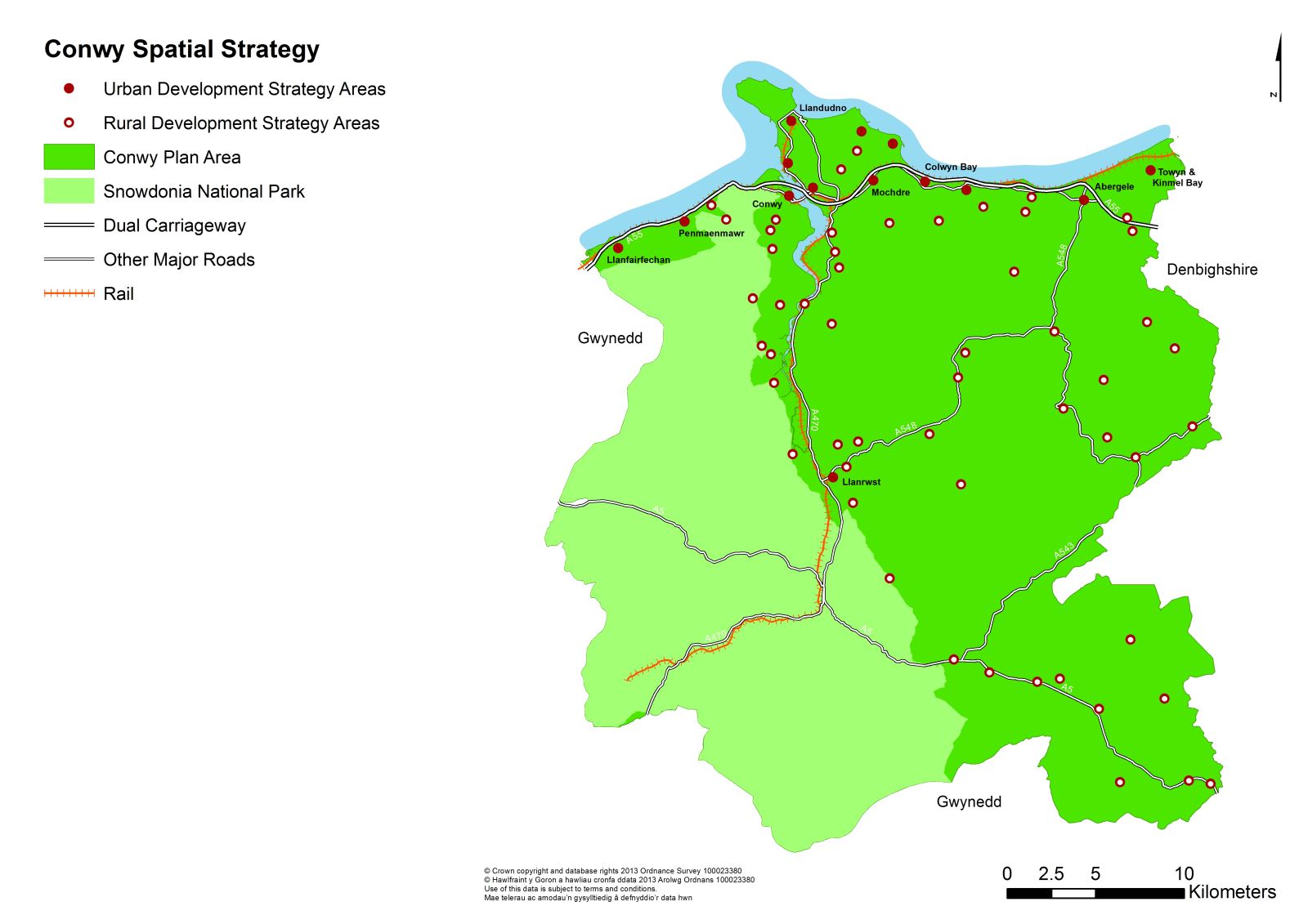
A number of development options were considered in relation to levels of housing & employment development (refer to BP/2 – ‘Population and Household Projections’) and the general spatial distribution (refer to BP/37 – ‘Growth Distribution Options Report’). In order to target development appropriately the Plan is also supported by a Hierarchy of Settlements policy to assist the formulation of the strategy (refer to BP/8 – ‘Hierarchy of Settlements and Settlement Boundaries’). In line with the key strategy components above, the preferred spatial option is promoted through the ‘Urban Development Strategy Area’ (UDSA) which directs approximately 85% of new development to either within or adjacent to existing urban settlements on green and brownfield lands along the coastal belt and the inland market town of Llanrwst. These locations are accessible to key facilities and services, are closely linked to employment areas and are supported by a strategic road and rail network. They form the predominant population areas in need of Affordable Housing for Local Need (AHLN), and they fully utilise the Wales Spatial Plan strategic hub of Conwy, Llandudno, Llandudno Junction and Colwyn Bay.
The development requirements of the Plan’s rural communities are promoted through a ‘Rural Development Strategy Area’ (RDSA) and are directed at meeting the needs of the Main Villages, Minor Villages and Hamlets. Collectively, the ‘Urban and ‘Rural Development Strategy Areas’ make up the Spatial Strategy for Conwy as illustrated in Diagram 1. The approach ensures that all communities have access to housing, employment and key facilities and services through the provision of appropriate sustained growth in all communities, but at the same time contributes to conserving the attractive coastline and landscape and the objective to retain the Welsh culture and language. Together with encouraging the right type of housing and employment, skills development and innovative design, provides a framework for contributing to a more balanced age structure and an economically active workforce.
3.2 Sustainable Growth for Conwy
Future population projections are fundamental in the determination of the number of additional dwellings and employment that will be required on sites across the Plan Area over the Plan period (refer to BP/2). Assumptions made in this regard impact on all other areas of the Plan. For example, future population growth will place additional pressure on the network of facilities necessary to support sustainable communities (waste, education, leisure, renewable energy etc). Policies within the Plan will ensure that the required community facilities will be developed in parallel with developments.
The capacity of the house building industry (refer to BP/31 – ‘Capacity of the House Building Industry’), the availability of suitable and deliverable land (refer to BP/21 – ‘Site Deliverability Assessment’), the views of the community and stakeholders (refer to the Consultation Report) and the social, economic and environmental impacts (refer to BP/10 – ‘Sustainability Appraisal and Strategic Environmental Assessment’) are all key pieces of evidence base that have played vital roles in informing the key strategy components and in determining the level of growth set out in this Strategy.
Having assessed the key components determining the appropriate level of sustained growth, the strategy will contribute to the delivery of the priority issues and provide approximately:
- 6,520 new housing units with a 10% contingency level of up to 7,170 new housing units to reflect natural population change, household size change and net in-migration (refer to BP/2, BP/3, BP/4, BP/5, BP/41).
- 2,350 new jobs with a contingency level of up to 2,585 new jobs to reflect natural population change, household size change and net in-migration (refer to BP/2, BP/3, BP/13, BP/14, BP/42).
- 1,800 jobs with a contingency level up to 1,980 new jobs to contribute to reducing out-commuting levels (refer to BP/2, BP/3, BP/13, BP/14, BP/42).
- 1,875 new affordable housing units (1,000 from new build) (refer to BP/2, BP/3, BP/7).
Additionally, the Strategy makes provision to accommodate the need for:
3.3 Housing Need, Type and Design
The Council will insist that housing is of the right type, size and tenure and is built to a high quality of design which incorporates renewable energy technologies. At the same time, the Council will adjust to an ageing population in terms of housing type.
3.4 Capacity of the House Building Industry
BP/31 demonstrates that the level of growth proposed by the Council of 6,520 dwellings (478 dwellings a year) is in line with what the house building industry are likely to be able to deliver. Any greater growth than this level would seriously undermine the deliverability of the Plan.
3.5 Employment Need
Evidence indicates that out-commuting levels can be reduced through the accommodation of additional jobs. As detailed in BP/3 – ‘Growth Level Options Report’ a further 1,800 jobs (15.5 hectares), with a contingency level up to 1,980 jobs (1.5 hectares), should be accommodated within the Plan to reduce out-commuting levels. There is no impact on the need for further housing development as those out-commuting reside in the Plan Area. A total of 36 hectares is proposed for employment use to be met via completions, commitments and new allocations.
The Council will develop a skills and knowledge based economy which optimises the value of the area’s natural resources, environment and cultural heritage. Together with the promotion of business and technology clusters and higher value employment offer a more economically active population will have contributed to overcoming the predicted decline in the economically active workforce. The type of employment offer and skills development is crucial to attracting a healthier workforce, a more balanced age structure and contributing to a younger population overall. To ensure a strategic and holistic approach to development and support the housing strategy, the employment land will be allocated predominantly in the strategic hub locations within the accessible UDSA and in the accessible settlement of Abergele.
3.6 A Consistent and Coherent Housing and Employment Growth Strategy
It is recognised that new economic growth will require a comparable level of homes to support population growth, specifically the growth of economically active residents (labour supply). As detailed in BP/2, BP/3 and BP/37, the Plan promotes a consistent and coherent growth strategy which ensures a holistic approach to employment and housing growth. This is supported by a number of mixed-use employment and housing sites that are phased to ensure delivery.
3.7 Providing Flexibility - Contingency Housing and Employment Sites
The LDP assumes that a high degree of housing and employment development will come forward from permissions, allocations, and in the case of housing, windfalls as a source of supply over the Plan period. However, whilst sites have been appraised to assess their deliverability, it is acknowledged that some may not come forward over the Plan period for a number of reasons. To accommodate this possibility, and for flexibility, the Plan therefore includes an additional element of housing and employment land (above the identified supplies) which has also been appraised and which is included within the Plan as a contingency to be released should some of the allocated sites not come forward as anticipated.
It is intended that the contingency be released where the Annual Monitoring Report (AMR) demonstrates that projected cumulative employment and housing targets as set out in the Plan are undermined in a way that impacts negatively on the strategy of the Plan. The basis for the release of contingency sites is detailed in Policy HOU/1 and evidenced in BP/41 – ‘Release of Contingency Sites’.
3.8 Delivering the Needs – Spatial Distribution
The Spatial Strategy guides the location of development and the provision of services and infrastructure towards the achievement of the vision and objectives, which are then delivered through policies in the next Section.
Supported and directed by Strategic Policy DP/1 – ‘Sustainable Development Principles’ and DP/2 – ‘Overarching Strategic Approach’, the Plan directs development towards the most sustainable locations within UDSA, as illustrated in the Key Diagram and detailed in Strategic Policies HOU/1 – ‘Meeting the Housing Need’ and EMP/1 – ‘Meeting the B1, B2 & B8 Office and Industrial Employment Need’.
The UDSA is supported by a RDSA setting out the approach to meeting the needs of the rural settlements within the Plan Area. In general, it is not anticipated that the relative size of settlements will change significantly but, in some cases, their functions need to be enhanced or strengthened, particularly where this enables needs to be met locally, leading to the creation of more sustainable communities.
The Implementation and Monitoring Sections in Appendices 1 and 2 detail where certain phasing is required in order to achieve delivery. This is supported by Strategic Policies HOU/1, EMP/1 and BP/30 – ‘Phasing Plan’.
3.9 Urban Development Strategy Area
The urban areas offer the greatest range of employment, facilities and services. These areas have a high degree of accessibility by public transport and other sustainable modes, and have the greatest need for AHLN. They benefit from a strong strategic rail and road corridor running through North Wales connecting the key hubs as recognised in the Wales Spatial Plan, which play an important role in sustaining the local economy. To enhance their roles and tackle the communities needs and issues, the Council will focus the majority of future housing and employment on a combination of Previously Developed Land (PDL) and greenfield land in these locations, primarily through existing commitments, windfall development and new allocations. To accommodate the new allocations for housing, the ‘settlement boundaries’ have been extended. Development outside the new settlement boundaries will not be allowed in these locations in order to protect the natural and historic environment, except in exceptional circumstances for employment development and for AHLN need on exception sites adjoining Llanrwst.
While each of the UDSAs has their own characteristics, a number of the urban locations experience close links and roles:
Llandudno, Llandudno Junction and Conwy
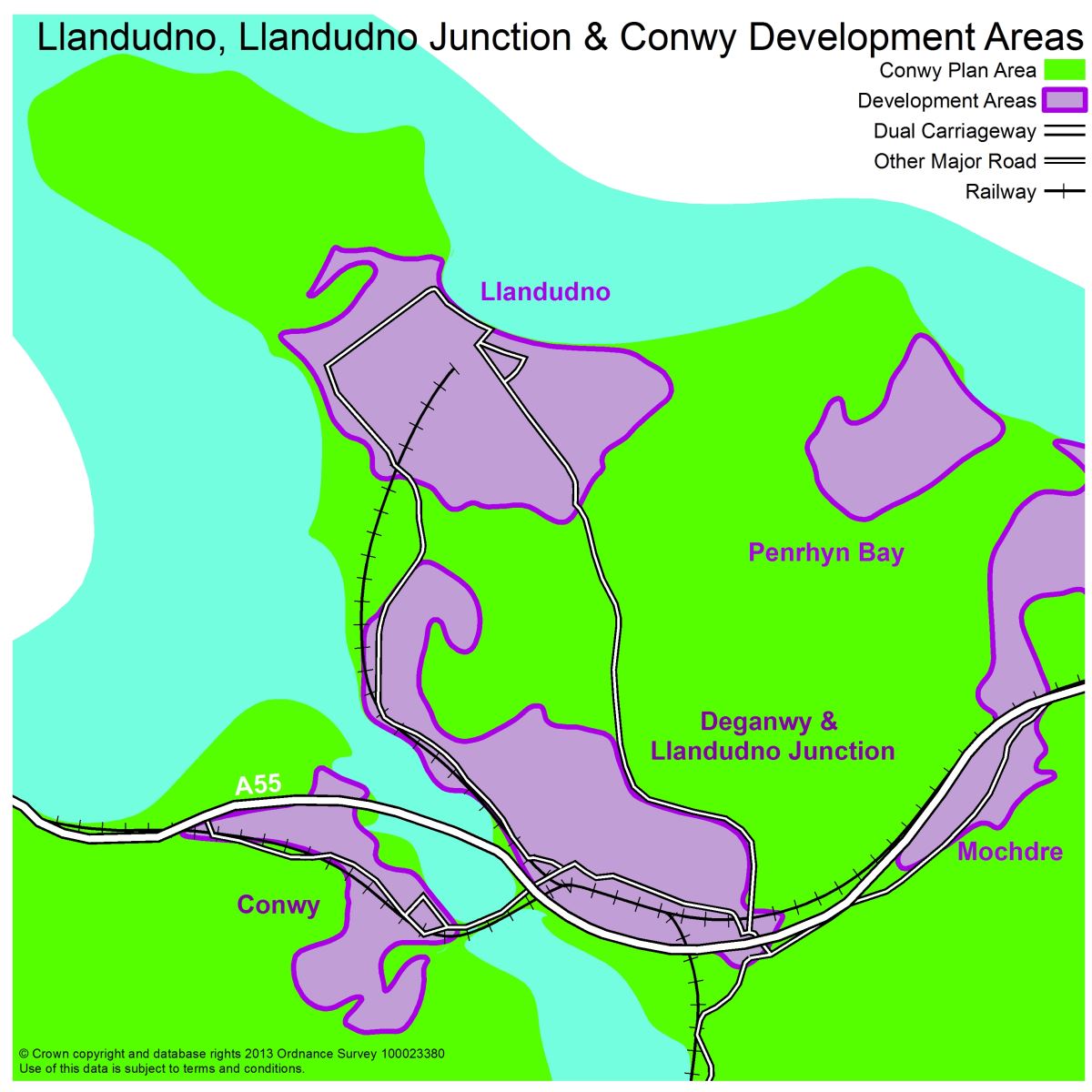
Llandudno, Llandudno Junction and Conwy provide an important cultural, social and economic role to the Plan Area and are situated along a strong strategic rail and road corridor. Over the Plan period it is projected that approximately 1905 (30%) new dwellings will be delivered on PDL and greenfield land within and on the edge of Llandudno, Llandudno Junction and Conwy to meet the demand for market and AHLN. This is inclusive of new homes that have already been completed or permitted. To partly meet the employment needs (B1, B2 & B8) within the Plan Area, approximately 15 hectares of employment land will be delivered in Llandudno Junction, Llandudno and Conwy over the Plan period from completions, commitments and new allocations.
The Town Centre of Llandudno will not accommodate any further major convenience or comparison retail up to 2012, but will be protected and, where possible, enhanced to ensure a balanced mix of uses that sustain activity throughout the day and evening. To improve accessibility and relieve congestion, an interchange facility will be provided at Llandudno Rail Station. The serviced tourism accommodation offer within Llandudno will be protected and, where possible, enhancement supported to cater for increasing demand, but will further diversify towards all year round tourism, including business tourism, and take advantage of our strategic links to Snowdonia National Park.
Llandudno Junction is promoted as a key economic hub at the heart of North Wales. Through the Llandudno Junction Masterplan, Llandudno Junction will see development improvements to create sustainable mixed uses and residential neighbourhoods with a mix of housing types and workplaces. The completion of the Welsh Government relocation to the area and the realisation of proposed mixed use sites will further advance the town as a gateway location in the future. The area’s connectivity between the residential element and Llandudno Junction town centre to the north of the rail line and the employment and retail land uses to the south will be improved, in particular through a new footbridge from the railway station to the leisure and entertainment area. New higher value employment opportunities and a rail-freight allocation will have promoted more sustainable travel and a shift from the car to more walking, cycling and public transport usage.
Within Conwy Town, convenience stores are overtrading which may be detrimental to local choice and quality of retail experience. Whilst there would be a qualitative benefit in the development of a retail facility that provides ‘top-up’ shopping on a day to day basis, it is recognised within this Plan that there are no appropriate sites within the town walls and the retention of the historic environment will take precedence over fulfilling the retail need. A balanced approach will be implemented in Conwy to ensure the needs of the community are contributed to and the historic assets protected and enhanced.
Colwyn Bay, Mochdre, Rhos-on-Sea and Old Colwyn
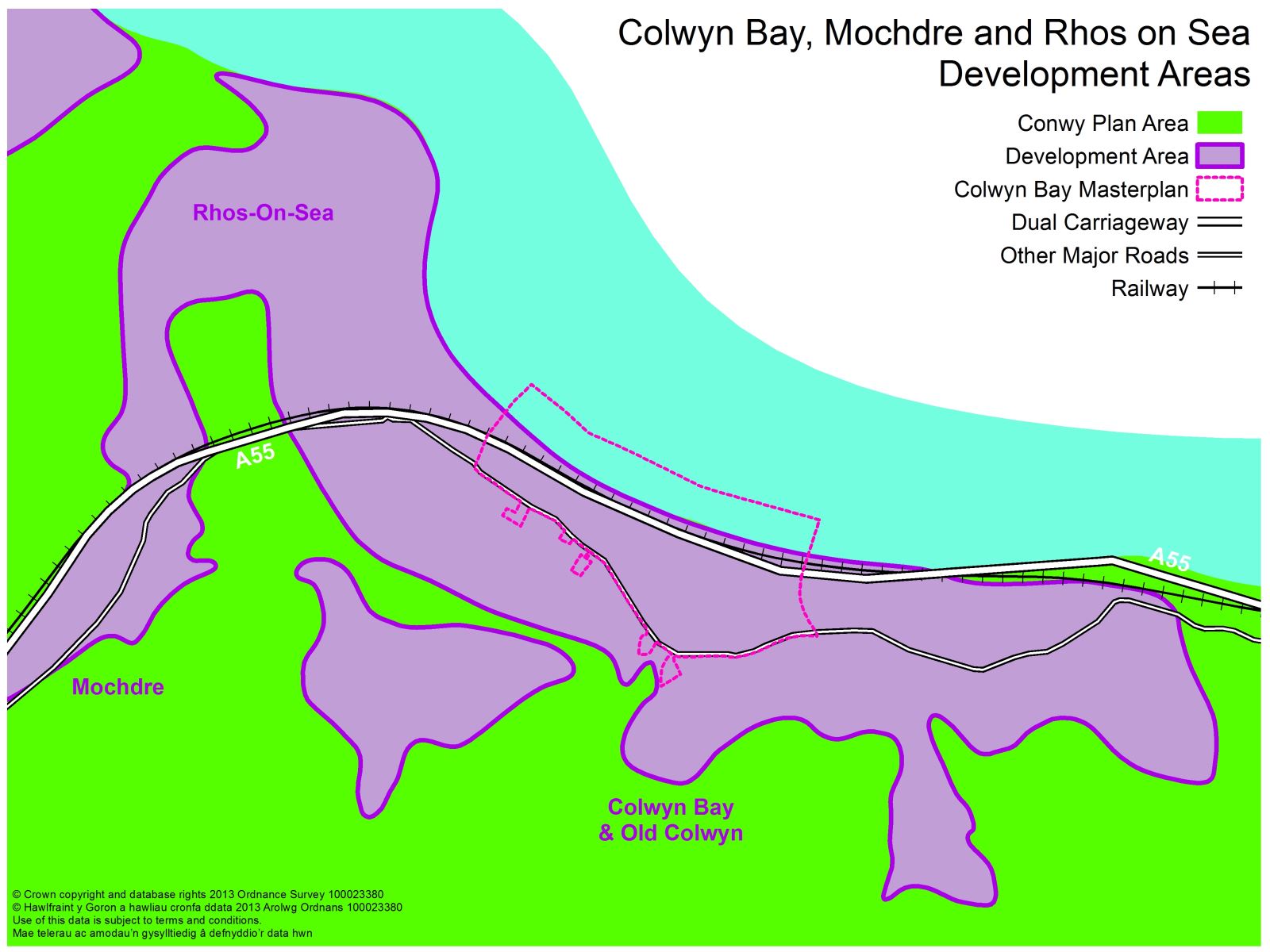
Colwyn Bay serves the retail, residential and economic needs of the surrounding catchment and is situated along a strong strategic rail and road corridor. To enhance its strategic role, tackle deprivation and achieve the overarching spatial objectives over the Plan period, it is projected that approximately 1,587 (25%) new dwellings will be delivered on PDL and greenfield land in these key areas, inclusive of new dwellings that have already been completed or permitted. Focussing housing development in this accessible location will significantly contribute to achieving the vision and objectives. Existing undeveloped employment (B1, B2 & B8) land will have been built in Rhos-on-Sea and Mochdre providing greater employment opportunities.
The town of Colwyn Bay will have realised its full potential through the implementation of the Colwyn Bay Masterplan. Through the Strategic Regeneration Initiative, the Colwyn Bay Masterplan will contribute to physical regeneration through improved housing stock, the control of Houses in Multiple Occupation (HMO), higher employment offer, accessibility to services and the overall environment. The area will have been regenerated, protected and enhanced to ensure a balanced mix of uses that create a thriving town centre and attractive environment that sustains the community.
Abergele, Towyn and Kinmel Bay (including Pensarn)
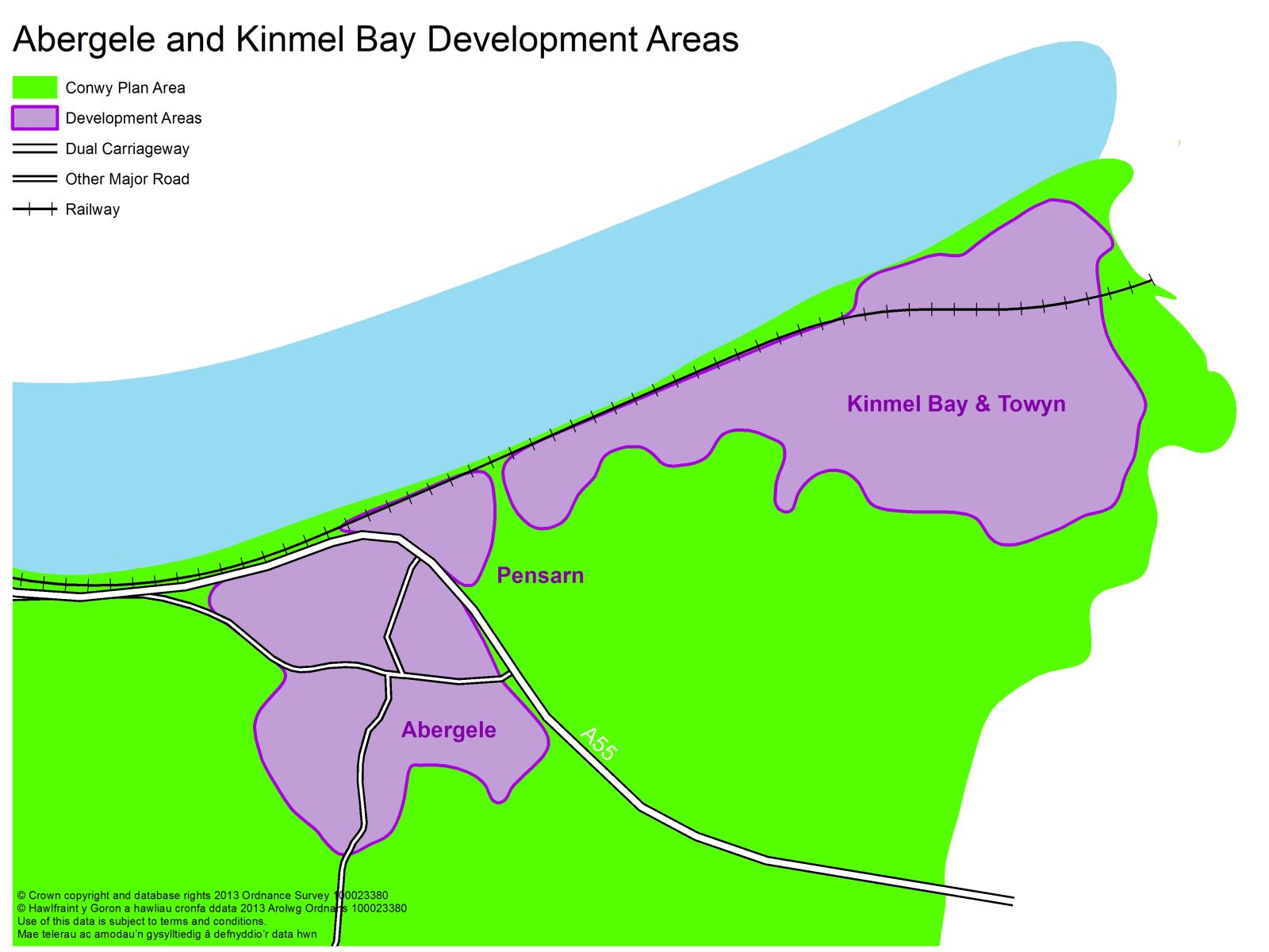
Abergele, Towyn & Kinmel Bay are key areas that serve the essential service needs of the surrounding catchment. Abergele will be the key growth area in the East to meet development needs, predominantly as a result of high flood risk constraints. Being located along a strong strategic road corridor and supported by existing facilities and services Abergele has the land availability and environmental capacity to deliver the majority of the housing and employment development in the area to meet the needs of the community and enhance the role of the area overall. An Abergele Masterplan will form the delivery vehicle to bring all the development opportunities together holistically, providing the means to ensure that the implications of new development impact positively on the wider areas as a whole. Over the Plan period it is projected that approximately 1,270 (20%) new dwellings will be delivered on previously developed and greenfield land in these key areas, inclusive of new homes that have already been completed or permitted. The level of growth and the new build allocations in Abergele are a clear reflection of poor past windfall developments coming forward, low commitments, high affordable housing requirements and constraints to the East of the County in Towyn and Kinmel Bay. Approximately 6 hectares of employment land (B1, B2 & B8) will be delivered in the Abergele area to meet needs and contribute to a reduction in out-commuting levels and car usage. The constraints associated with the Abergele Business park and related poor land take-up will have been realised through the relocation of employment land to more accessible locations with direct access to the A55 corridor. Abergele, Kinmel Bay and Towyn will also benefit from improvements having been included in the Strategic Regeneration Area Initiative.
To realise the development potential in Abergele and lessen impact on the town centre, a Traffic Improvement Scheme will manage the volume of traffic, congestion and prevent pressure on the surrounding road network. Greater sustainable and safer cycle links will be realised through the completion of the SUSTRANS National Route 5 and new cycle/pedestrian bridge at the new Foryd Harbour development in Kinmel Bay.
Towyn and Kinmel Bay are subject to high flood risk levels which will result in limited development opportunities for the future. The Plan recognises that such a lack of development is likely to be to the detriment of the area due to the possibility of a number of brownfield sites becoming and remaining vacant in these locations. Action Plans will be prepared to assist in preventing further decline of the area concentrating on principle links, gateways and landmarks which attract more attention from residents and tourists.
Llanfairfechan & Penmaenmawr
Llanfairfechan and Penmaenmawr are smaller urban settlements which are self contained with a range of essential facilities and services. Over the Plan period approximately 317 dwellings (5% of the housing need) will be accommodated in these locations, predominantly to meet the affordable housing requirement.
Llanrwst
Llanrwst is classed as an urban area and forms part of the UDSA as a result of its size, the facilities and services that it offers and the support it provides to the Main and Minor Villages. Llanrwst is located in a rural setting some 13 miles south of Conwy town. It is not as accessible in terms of its position and access to the strategic road and rail network and to employment opportunities. For these reasons, the urban area of Llanrwst will accommodate an element of market, AHLN and employment to contribute to demand, but the level of development will be to a lesser extent to what is proposed in the urban coastal locations to protect its rural character, natural and built environment.
3.10 Rural Development Strategy Area
The strategy for the rural area is to promote a sustainable rural economy and contribute to meeting AHLN in the Main Villages, Minor Villages and Hamlets, to eliminate any social disadvantages whilst at the same time conserving their natural and built character. A number of the rural settlements within the Settlement Hierarchy (see Policy DP/2) have distinctive individual roles, but at the same time support and provide essential links to other communities.
Farming remains a vital part of the rural economy and is important in protecting the character and appearance of the landscape. Over the years there has been some diversification from the traditional rural activities primarily by the reuse of farm and other buildings for business purposes. This has not only helped to retain employment within rural areas but has also enabled some farms to remain operational as the diversified activity supports the farming business. By allowing suitable conversions of buildings for business use or live work enterprises, including tourism, the Council aims to support the rural economy. However residential conversions may be more appropriate in some locations and for some types of building to support business and AHLN.
The Council will continue to support a balanced approach to diversification through the conversion of rural buildings provided that it does not result in unacceptable environmental impacts and the character of the countryside is not adversely affected. Accepting the lack of suitable land within rural settlements, new employment opportunities will have been realised through a flexible approach to new development on non-allocated sites. On such sites, new skills and training will have been provided.
The Plan Area is an important area for tourism. The countryside is itself an attraction with plenty of opportunities for recreation. The strategy will support improved access to, and enjoyment of, the countryside throughout the rural Plan Area.
Main Villages

Dwygyfylchi*, Glan Conwy, Llanddulas and Llysfaen are categorised as Tier 1 Main Villages. Betws-yn-Rhos, Cerrigydrudion, Dolgarrog*, Eglwysbach, Llanfair Talhaiarn, Llangernyw, Llansannan, Tal-y-Bont* / Castell and Trefriw* are categorised as Tier 2 Main Villages. They provide an important range of facilities and services, including shopping, to their surrounding rural settlements. The Tier 1 Main Villages provide a higher level of facilities and services than the Tier 2 Main Villages and have greater sustainable access to the higher order urban areas. It is important that their existing level of facilities and services are protected wherever possible. The Tier 1 Main Villages will provide a combination of market value and AHLN from existing commitments, on allocated sites and from windfall development, to realise the spatial objectives for the delivery of AHLN and protection of the natural and historic environment. Within the Tier 2 Main Villages, the Council will seek to deliver 100% AHLN only on allocated sites and windfall sites within the settlement boundaries to represent the level of facilities and services and to safeguard the Welsh language. To provide an element of flexibility, market dwellings will be permitted in exceptional circumstances on allocated sites and windfall sites within the Tier 2 Villages as a means to deliver affordable housing on-site, subject only to financial viability. Such windfall schemes will generally be smaller than those permitted in the Urban Development Strategy Areas, no more than 10 dwellings, and will be phased in line with the provision of infrastructure. Small scale 100% AHLN exception sites may be permitted outside, but on the edge of, the settlement where it meets local need. Smaller retail, commercial and leisure development will be permitted at a scale appropriate to the function of the settlement and where it enhances sustainability.
*Falls partly within the Snowdonia National Park
Over the Plan period, approximately 950 dwellings (15% of the housing requirement) will be distributed between these settlements (inclusive of the Minor Villages and Hamlets) through existing commitments, windfall sites and new allocations primarily in the Tier 1 & 2 settlements. Approximately 15% of the employment requirement (B1, B2 & B8) will be allocated and permitted in these locations to support sustainable development. However, the Plan recognises the development constraints in Dolgarrog, Tal y Bont and Trefriw and the links with Snowdonia National Park. In Dolgarrog, the existing employment site at the former Aluminium Works will have been safeguarded for mixed use (employment/leisure/tourism/housing) uses to provide all year round tourism and recreational job opportunities.
Minor Villages
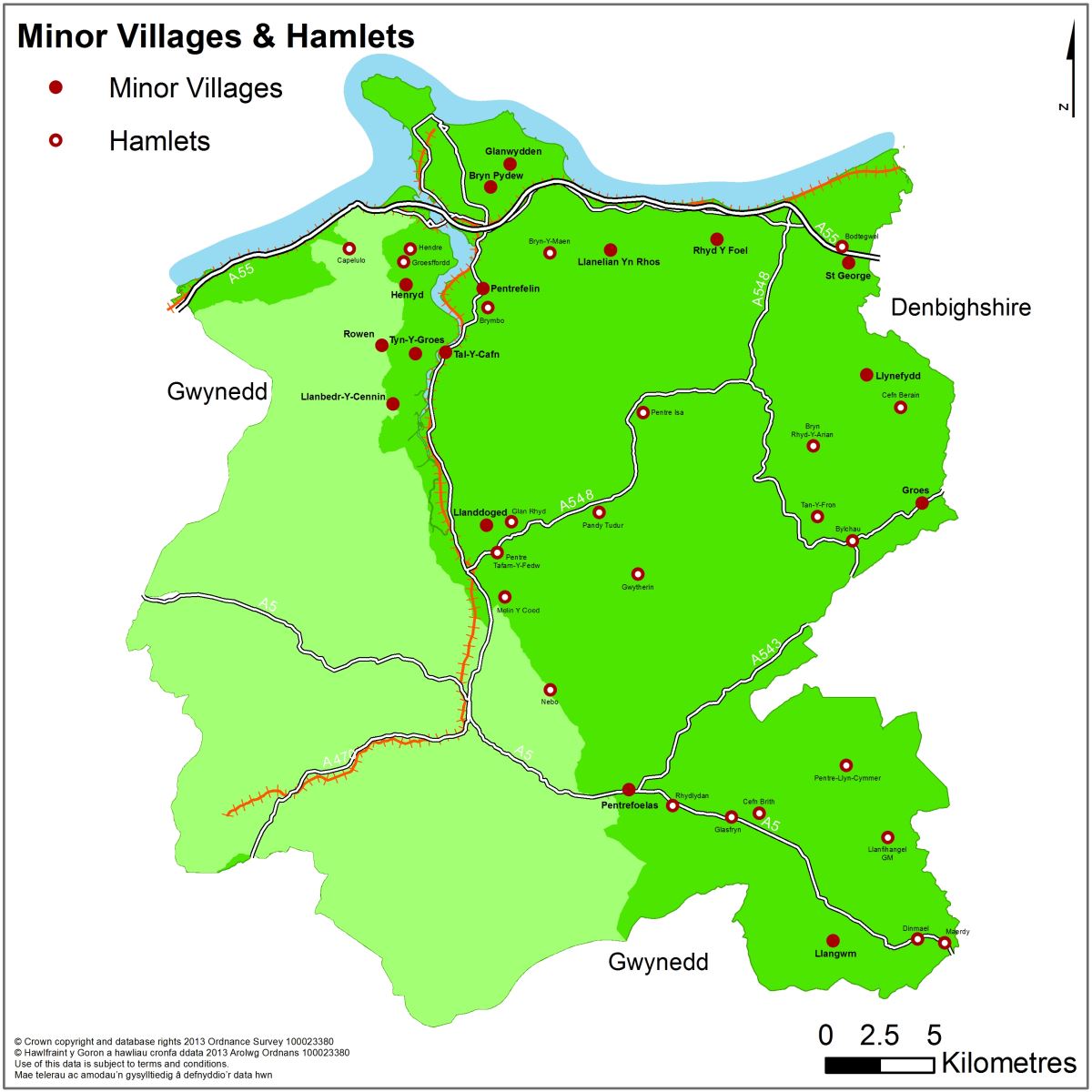
The Villages of Bryn Pydew, Glanwydden, Groes, Henryd, Llanbedr-y-Cennin*, Llanelian, Llanddoged, Llangwm, Llannefydd, Pentrefelin, Pentrefoelas, Rhyd-y-Foel, Rowen*, St George, Tal-y-Cafn and Tyn-y-Groes are smaller settlements where limited development is allowed to meet the needs of the community, safeguard the existing facilities and services and protect the natural and built environment. There are no settlement boundaries for Minor Villages and no allocations are made for market housing or employment. However, to meet the needs of the community, the Council will seek to deliver 100% AHLN only on windfall sites within the confinements of the settlement or where single or small groups of new dwelling estates (up to 5 dwellings) represent a form of infilling and relates physically and visually to the settlement. The level of development should represent the level of facilities and services and safeguard the Welsh language. To provide an element of flexibility, market dwellings will be permitted in exceptional circumstances on windfall sites within the confinements of the settlement as a means to deliver affordable housing on-site, subject only to financial viability. Small scale 100% AHLN exception sites may be permitted outside on the fringe of the main settlement confinements, where it meets local need.
Hamlets
The Hamlets of Bodtegwel, Bryn-y-Maen, Brymbo, Bryn Rhyd-y-Arian, Bylchau, Capelulo*, Cefn Berain, Cefn Brith, Dinmael, Glan Rhyd, Glasfryn, Groesffordd, Gwytherin, Hendre, Llanfihangel GM, Maerdy, Melin y Coed, Nebo*, Pandy Tudur, Pentre-llyn-cymmer, Pentre Isa, Pentre Tafarn-y-Fedw, Rhydlydan and Tan-y-Fron are smaller in size than the Minor Villages and have relatively few facilities and services. The Hamlets will experience very little development over the Plan period. Small scale development proposals which help to diversify rural economy, create improved links to the National Park and provide key community facilities will be encouraged. Hamlets may be appropriate for agricultural or forestry worker dwellings, conversions to dwellings for AHLN, provision of a single AHLN, farm diversification schemes and other developments with specific locational needs.
*Falls partly within the Snowdonia National Park
Open Countryside
Within the open countryside, agricultural or forestry worker dwellings, conversions to dwellings for AHLN and farm diversification schemes will be considered where it meets local identified need, supports the economy and protects the open countryside.
3.11 Key Diagram
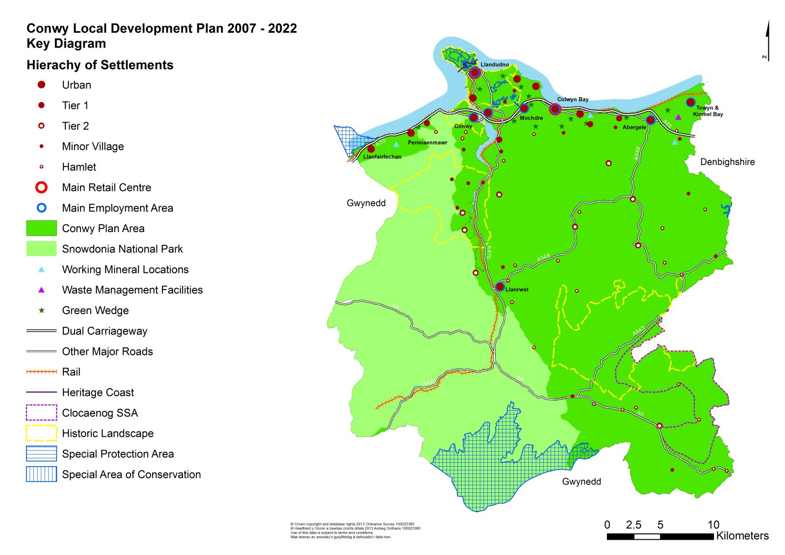
The Key Diagram illustrates the LDP Strategy at a Plan Area-wide scale. This is supported by an additional key strategic diagram on transport strategy, retail hierarchy and Proposals Map. This diagram, outlines the broad spatial principles of the Strategy and are not intended to be detailed or site specific. The preferred policy directions are reflected in the diagrams, to facilitate community consultation and sustainability appraisal.